
YouTube
4K aerial cinematic drone exploration of Musikot Khalanga, Rukum West (Video: Hemanta Rai Official)
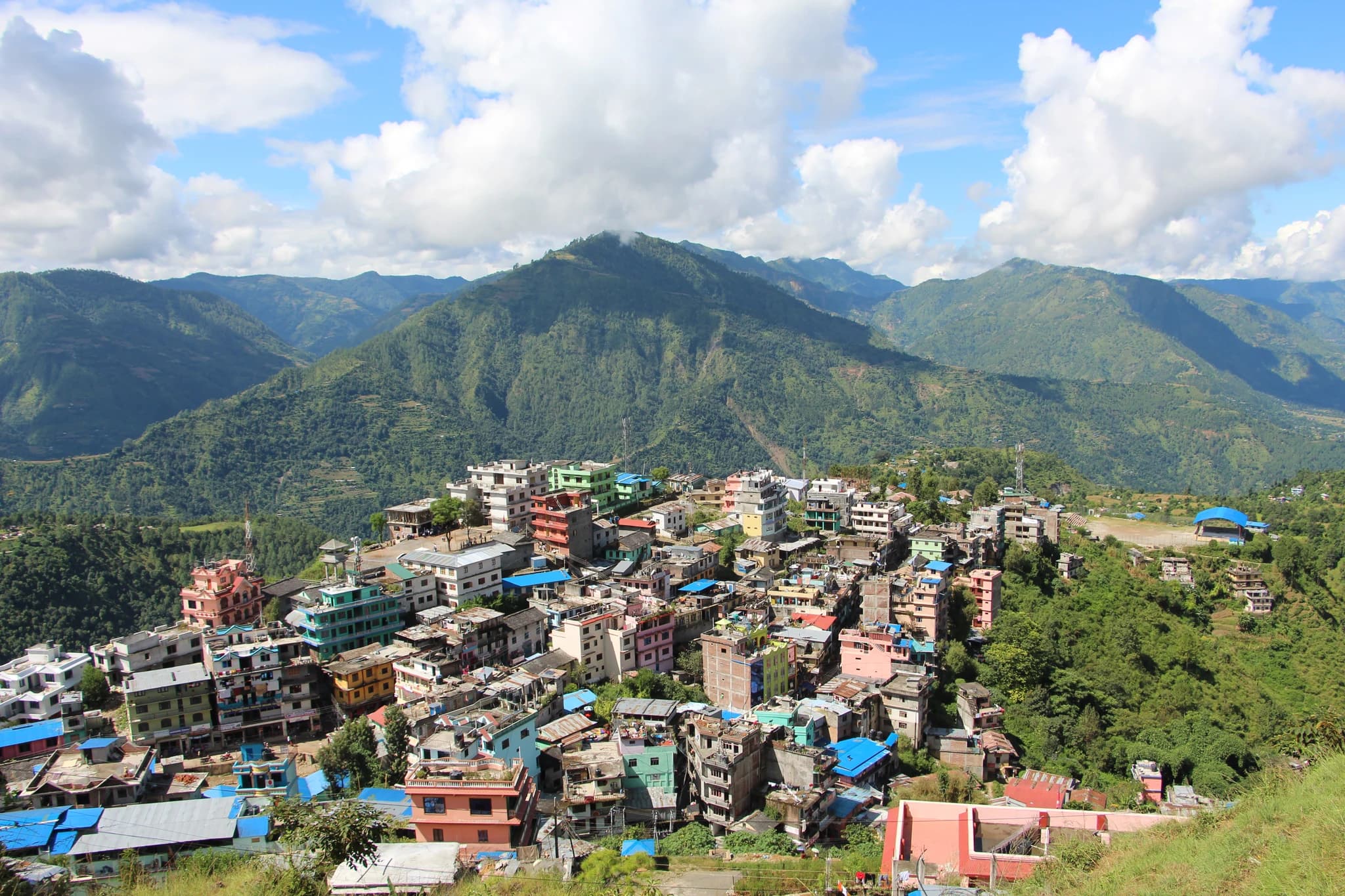
Perched dramatically along a high mountain spine commanding the Sani Bheri river basin, the Musikot Khalanga Historic Ridge (मुसिकोट खलङ्गा ऐतिहासिक गढी) represents the historical and administrative heart of Rukum West. This strategic hilltop was the fortified citadel seat of the medieval Musikoti Rajas, one of the prominent principalities of the Baise Rajya confederacy before its incorporation into unified Nepal in 1787 CE. The ridge preserves the historic ruins of Musikot Durbar, ancient defensive stone bastions, and the royal palace temple complex restored under archaeological oversight. Walking along the traditional stone-paved paths through the old Khalanga settlement, visitors encounter distinctive vernacular stone masonry architecture, panoramic 360-degree viewpoints stretching north toward the snow-capped Sisne range, and rich cultural lore surrounding the founder-maid Musi and the martial history of the Karnali hills.
Perched dramatically along a high mountain spine commanding the Sani Bheri river basin, the Musikot Khalanga Historic Ridge (मुसिकोट खलङ्गा ऐतिहासिक गढी) represents the historical and administrative heart of Rukum West. This strategic hilltop was the fortified citadel seat of the medieval Musikoti Rajas, one of the prominent principalities of the Baise Rajya confederacy before its incorporation into unified Nepal in 1787 CE. The ridge preserves the historic ruins of Musikot Durbar, ancient defensive stone bastions, and the royal palace temple complex restored under archaeological oversight. Walking along the traditional stone-paved paths through the old Khalanga settlement, visitors encounter distinctive vernacular stone masonry architecture, panoramic 360-degree viewpoints stretching north toward the snow-capped Sisne range, and rich cultural lore surrounding the founder-maid Musi and the martial history of the Karnali hills.
3 available
1 available
YouTube
4K aerial cinematic drone exploration of Musikot Khalanga, Rukum West (Video: Hemanta Rai Official)
Discover More

Spread across an expansive subtropical plateau along the eastern banks of the Bheri River, Chaurjahari Valley (चौरजहारी उपत्यका) is the largest and most striking flat river plain in the mountainous Karnali Province. Perched at an agreeable elevation of approximately 780 meters, this fertile agricultural wonderland is renowned as the breadbasket of Western Rukum, blanketed with flourishing paddy fields, golden wheat terraces, and sun-ripened citrus orchards. The Government of Nepal has designated Chaurjahari as one of the ten model Smart New Cities along the Mid-Hill Highway corridor, blending historic Newari-influenced bazaar quarters with modern town planning. The valley offers sweeping views of the turquoise Bheri River winding beneath rugged limestone cliffs, historic pedestrian suspension bridges linking Rukum West with Jajarkot, and panoramic vantage points from the surrounding hilltops.

Located at Tharpu in Musikot Municipality, Digre Sai Kumari Bhagawati Temple (डिग्रे शाईकुमारी भगवती मन्दिर) is one of the most revered and ancient Shakta pilgrimage shrines in Western Nepal, cataloged under national archaeological monument inventory NP-RK-06. The sanctuary enshrines a sacred manifestation of Goddess Durga and houses a historic bronze temple bell dating back to 1641 BS (1584 CE). According to sacred local legend, the subterranean inner sanctum contains a natural limestone fissure traditionally believed to connect directly to the waters of the sacred Sani Bheri River. The temple is the focal point of an immense five-day religious fair held annually from Haribodhini Ekadashi to Kartik Purnima, drawing tens of thousands of pilgrims from across Karnali and Lumbini provinces. During the festival, devotees participate in vibrant spiritual rites and witness the iconic Sagal Nach (martial stick dance), creating an unforgettable cultural and spiritual spectacle.

Nestled among the terraced hills of Banfikot in Rukum West, Syarpu Lake (स्यार्पू ताल) is the premier freshwater gem of the Mid-Western hills. Spanning a water surface of approximately 49 hectares within a wider 2.6-square-kilometer catchment basin, this serene body of water reflects rolling green pine ridges and terraced village farms. The lake is fed by pristine natural springs and the cascading waters of the Simaichhari waterfall, supporting thriving local carp fisheries and vibrant biodiversity. Visitors can glide across its tranquil turquoise waters on traditional wooden rowboats, hike scenic rim trails connecting lakeside homestays, and savor fresh local fish prepared by welcoming Magar and Chhetri communities. The annual Syarpu Tourism Festival celebrates the lake's cultural and ecological prominence, making it an essential eco-tourism and nature retreat in Karnali Province.

Ajayamerukot is a monumental medieval archaeological citadel and palace complex established in the 13th to 14th century CE as the royal winter capital of the Katyuri and Doti Rainka Kings. Perched defensively atop an isolated mountain spur in Ward 2 of Ajaymeru Rural Municipality at an altitude of 1,313 metres, the site is bordered on three sides by sheer ravines carved by the Chamdola and Baunera streams. The extensive archaeological precinct preserves the foundation platforms of a multi-tiered stone royal palace, expansive paved courtyards, an assembly hall (Baithak), carved Shikhara-style stone dewals, and defensive ramparts. An exceptional architectural marvel of the site is the subterranean Rani Naula (रानी नाउला), an intricately dressed stone step-well featuring arched corridors and classical Katyuri decorative friezes. Recognized as an official Department of Archaeology monument under ID NP-DD-04 and nominated on Nepal's UNESCO World Heritage Tentative List, Ajayamerukot stands as one of the most significant medieval monarchical complexes in the Himalayas.

Alapeshwar Cave (locally known as Alpeswor Gupha or Alapu Cave), nestled within the forested hills of Kusma Municipality Ward 7 near Gyadichaur and the Silmi forest corridor, is an extraordinary natural speleological cave network in Parbat District. Discovered in recent decades by local community members, the cave extends several hundred metres into subterranean limestone bedrock, offering an intriguing subterranean exploration destination for eco-tourists and adventure travelers. The interior of Alapeshwar Cave features multiple natural limestone chambers linked by winding rock corridors. Over tens of thousands of years, mineral-rich seepage water has sculpted spectacular calcite formations, including delicate stalactites hanging from cavern ceilings, massive stalagmites rising from the floor, flowstone curtains, and crystalline rock terraces. In several chambers, clear subterranean spring water flows over the smooth limestone floor, creating natural underground wading pools and tranquil echo chambers. Local development committees have installed solar-powered illumination along the main walking galleries, safe metal ladders, and protective handrails to facilitate visitor access without disturbing the delicate cave ecology and resident microbat colonies. Unlike heavily visited commercial caves, Alapeshwar retains a raw, uncommercialized subterranean ambiance that rewards curious travelers exploring the diverse canyon landscape of Kushma.

Amargadhi Fort is a monumental late 18th-century stone military fortification perched at an elevation of 1,901 metres along the crest of the Mahabharat range in Khalanga, Dadeldhura. Constructed in 1790 CE (1847 BS) by Gorkhali Commander Bada Kaji Amar Singh Thapa following the unification of the Far-Western hill principalities, the citadel commanded vital strategic mountain trade and troop routes between Doti, Kumaon, and the Mahakali basin. Enclosed by massive stone bastion ramparts punctuated with defensive cannon embrasures, the inner fortress encompasses twenty-two subterranean vaulted chambers that served as troop barracks and munitions depots, a central Kotghar armory, and a shrine dedicated to Ugra Bhairav. Cataloged under Department of Archaeology monument identification NP-DD-08, the citadel offers sweeping panoramic vistas across the terraced valleys and surrounding pine-clad ridges.