YouTube
Murma Top Viewpoint Travel Video
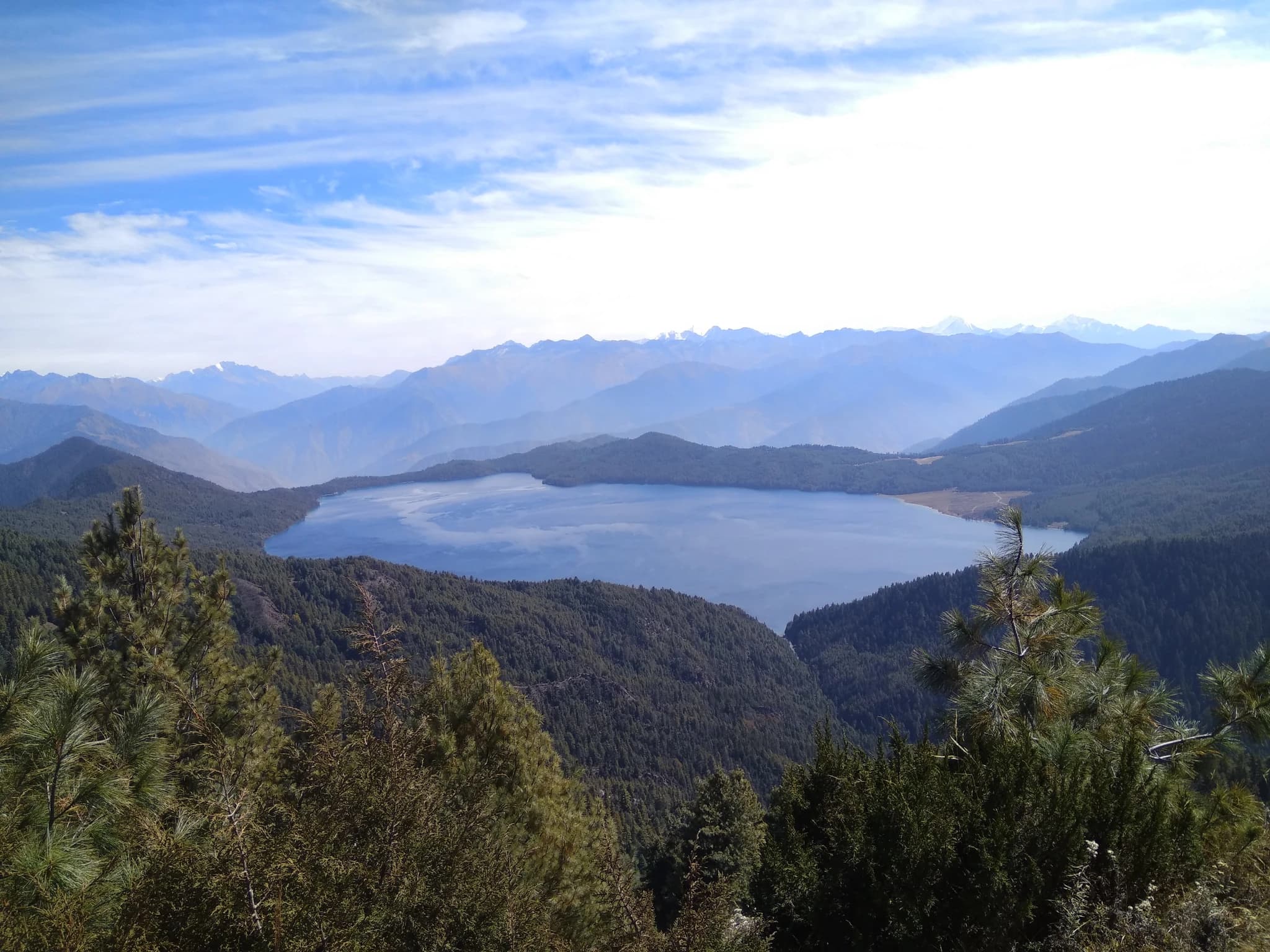
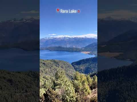
Perched majestically at an elevation of approximately 3,710 meters on the northwestern ridgeline of Rara National Park, Murma Top (मुर्मा टप) is widely celebrated as the ultimate panoramic vantage point for beholding the breathtaking grandeur of Rara Lake and the high Karnali Himalayas. While the sapphire shores of Nepal's largest freshwater lake offer tranquil lakeside beauty from below, it is from the lofty heights of Murma Top that its magnificent, crescent-shaped expanse is revealed in full glory, cradled amidst an emerald amphitheater of ancient blue pine, spruce, and rhododendron forests. The ascent to Murma Top begins with a scenic ridge trek departing from the traditional settlement of Murma Village, winding gently upward through fragrant alpine meadows, subalpine birch groves, and grazing pastures frequented by Himalayan sheep. At the summit stands a wooden panoramic observation view tower, erected to provide an unobstructed 360-degree vista spanning far across western Nepal. To the east and south, the glistening turquoise waters of Rara Lake reflect the sky like an enormous Himalayan mirror, while across the horizon soar the glaciated ramparts of Kanjiroba Himal, Chhayanath Peak, Sisne Himal, and the distant Saipal range. Murma Top is also a vital natural vantage point for sunrise and sunset photography, as early dawn paints the distant snow peaks in shades of amber and rose gold, casting soft mist over the tranquil water surface. Visited by both day-trippers from the Rara shoreline and long-distance trekkers acclimatizing along the classical Jumla–Rara trail, Murma Top represents an indispensable highlight of any wilderness expedition into Mugu District.
Perched majestically at an elevation of approximately 3,710 meters on the northwestern ridgeline of Rara National Park, Murma Top (मुर्मा टप) is widely celebrated as the ultimate panoramic vantage point for beholding the breathtaking grandeur of Rara Lake and the high Karnali Himalayas. While the sapphire shores of Nepal's largest freshwater lake offer tranquil lakeside beauty from below, it is from the lofty heights of Murma Top that its magnificent, crescent-shaped expanse is revealed in full glory, cradled amidst an emerald amphitheater of ancient blue pine, spruce, and rhododendron forests. The ascent to Murma Top begins with a scenic ridge trek departing from the traditional settlement of Murma Village, winding gently upward through fragrant alpine meadows, subalpine birch groves, and grazing pastures frequented by Himalayan sheep. At the summit stands a wooden panoramic observation view tower, erected to provide an unobstructed 360-degree vista spanning far across western Nepal. To the east and south, the glistening turquoise waters of Rara Lake reflect the sky like an enormous Himalayan mirror, while across the horizon soar the glaciated ramparts of Kanjiroba Himal, Chhayanath Peak, Sisne Himal, and the distant Saipal range. Murma Top is also a vital natural vantage point for sunrise and sunset photography, as early dawn paints the distant snow peaks in shades of amber and rose gold, casting soft mist over the tranquil water surface. Visited by both day-trippers from the Rara shoreline and long-distance trekkers acclimatizing along the classical Jumla–Rara trail, Murma Top represents an indispensable highlight of any wilderness expedition into Mugu District.
3 available
1 available
YouTube
Murma Top Viewpoint Travel Video
Discover More

Rising in majestic spiritual isolation amid the glaciated peaks of northeastern Mugu at an altitude of approximately 4,500 meters, Chhayanath Dham (छायाँनाथ तीर्थ / छायाँनाथ धाम) stands as one of the holiest, most remote, and mythologically revered Shaiva-Shakti pilgrimage sanctuaries in the entire Himalayan realm. Eponymously immortalized in the name of Chhayanath Rara Municipality, this sacred sanctuary is venerated in classical Hindu tradition and regional epics as the hallowed site where the spine and divine shadow (*Chhaya*) of Sati Devi fell to earth as Lord Shiva carried her lifeless body in his divine grief-stricken dance across the cosmos. Geographically anchored within Ward 1 of Mugum Karmarong Rural Municipality beneath the towering crags of Chhayanath Peak (~5,200m) and the eastern Kanjiroba massif, the sanctuary comprises natural rock sanctums, open-air stone altars, and sacred glacial tarns known as Dudh Kunda. For eleven months of the year, the sanctum remains engulfed in deep snow and ice, while its venerated silver idol (*Chhayanath Murti*) is guarded in the winter repository temple at Chainagaun near Gamgadhi. Each year during the monsoon festival of Janai Purnima (Shrawan Shukla Purnima), a grand state and community procession carries the sacred idol across five rigorous days of wilderness trekking through alpine gorges, high birch forests, and glacial moraines to the holy Dham. Thousands of devout pilgrims, ascetics, and regional shamans (*Dhamis*) from across Karnali and western Nepal undertake this arduous pilgrimage to perform sacred ablutions in the icy glacial waters, break ritual bonds of worldly suffering, and offer worship amidst swirling Himalayan mists and hypnotic shamanic drums. With its dramatic blend of raw trans-Himalayan wilderness, profound mythological significance, and living intangible spiritual tradition, Chhayanath Dham represents the supreme sacred beacon of Mugu.

Nestled gracefully on the sun-drenched southeastern terraced mountain slope at approximately 3,200 meters elevation, Murma Village (मुर्मा गाउँ) is the sole preserved indigenous human settlement remaining within the immediate mountain amphitheater enclosing Rara Lake. When Rara National Park was officially established in 1976 AD (2032 BS), the ancient lakeside settlements of Chapru and Rara were entirely relocated to the Terai plains of Banke District. Murma, situated above the designated lake basin in Ward 9 of Chhayanath Rara Municipality, was uniquely preserved, safeguarding centuries of unbroken Khas heritage and traditional mountain lifestyle. The architecture of Murma represents an authentic living museum of vernacular western Himalayan craftsmanship. Clustered densely against the hillside, the two-to-three-story homes are constructed with dry-chiseled fieldstone, massive rough-hewn pine timbers, and flat earthen mud-slate roofs (*poko* or *chhato*). In this distinctive stepped arrangement, the flat rooftop of each lower residence serves as the front courtyard, grain-drying terrace, and threshing floor for the home above. Hand-notched timber log ladders (*lihno*) connect the ascending terraces, while intricately carved wooden lattice windows (*aankhijhyal*) and wooden balconies adorn the facades. In recent years, Murma has emerged as a celebrated model for sustainable community-based eco-tourism and cultural homestays. Operated with warm mountain hospitality, local homestays offer visitors wholesome traditional meals prepared from native highland crops—including buckwheat pancakes (*fapar ko roti*), roasted barley flour (*tsampa*), organic mountain potatoes, and fragrant wild Timur pepper. Serving as the primary trailhead and community gateway for travelers hiking to Murma Top, Murma Village offers an enriching glimpse into the resilient cultural soul of Karnali.

Rara Lake is Nepal's largest lake, a pristine alpine jewel set at 2,990 metres altitude in the remote Mugu district of Karnali Province. Covering 10.8 square kilometres, the lake is renowned for the extraordinary clarity and colour of its water, which shifts between deep blue and turquoise depending on time of day and weather conditions. The surrounding Rara National Park, established in 1976, is Nepal's smallest national park by area but one of its most pristine. The lake sits in a bowl of dense juniper, pine, and Himalayan oak forests, backed by snow-dusted ridges. Wildlife in the park includes Himalayan black bears, red pandas, musk deer, leopards, grey langurs, and over 200 bird species. The lake itself contains the Asiatic snow trout, a protected species. Reaching Rara Lake requires a short flight from Nepalgunj or Jumla to Talcha Airport, or a multi-day trek from Jumla (approximately 4-5 days each way). Activities at the lake include trekking around the 13 km perimeter, photography, wildlife watching, and camping. Because of its remoteness, Rara sees relatively few visitors, preserving its exceptional natural character. The best seasons are September to November (post-monsoon, clear skies) and April to May (spring flowers). The lake is partially frozen and inaccessible in mid-winter from December through February.

Known as Ama Yangri Peak, and also called Ama Yangri or Ama Yangri Danda, this spectacular Himalayan viewpoint in the Helambu region of Sindhupalchok district is one of Nepal's finest short trekking destinations. Rising to an elevation of approximately 3,771 meters, the peak is revered by the local Hyolmo (Yolmo) community, who consider it a sacred mountain blessed by a protective mother deity, from which the name "Ama" (Mother) is derived. The trek to the summit passes through enchanting rhododendron and pine forests, colorful prayer flags, traditional monasteries, and peaceful Hyolmo villages, offering a perfect blend of natural beauty and cultural heritage. From the summit, visitors are rewarded with breathtaking 360-degree panoramic views of the Langtang, Jugal Himal, Dorje Lakpa, Ganesh Himal, Gaurishankar, and even Mount Everest on exceptionally clear days. The peak is especially famous for its mesmerizing sunrise, when the first rays of light illuminate the snow-capped Himalayas in brilliant shades of gold and orange. Spring and autumn provide the best trekking conditions, with blooming rhododendrons, pleasant weather, and crystal-clear mountain vistas. Whether you're seeking a rewarding Himalayan hike, spectacular photography, or a peaceful spiritual escape, Ama Yangri Peak (Ama Yangri/Ama Yangri Danda) offers one of the most unforgettable viewpoints in central Nepal.

Australian Camp, historically known as Thula Kharka (Great Pasture), is a renowned scenic ridge viewpoint and serene trekking settlement situated at an elevation of 2,060 metres in Kaski. Located along the ridge above Kande village and Dhampus, the site gained its popular name in the 1990s when Austrian (and later Australian) expeditioners utilized the expansive meadow as a peaceful base. The camp offers an unobstructed 360-degree panorama of the central Himalayas, providing close-up perspectives of Annapurna South, Hiunchuli, Machhapuchhre, and Lamjung Himal rising dramatically above the Modi Khola valley. The sunrise and sunset from the camp's grassy ridge crest are legendary, illuminating snow giants against alpine skies. Accessible via an easy 1.5 to 2-hour uphill hike through rhododendron and oak forests from Kande highway, Australian Camp serves as an ideal introductory day-hike, family trek, or launching point for the Mardi Himal and Dhampus circuit trails. Well-appointed lodges and camping grounds provide comfortable mountain hospitality.

The Badagaun-Kaiyan Suspension Bridge (frequently referred to as the Kushma-Mudikuwa Bridge or Kaiya Suspension Bridge), spanning between Badagaun in Kusma Municipality and Kaiyan/Mudikuwa on the southern canyon plateau, is among the highest pedestrian suspension footbridges in Nepal and all of South Asia. Completed in 2013 AD (2070 BS) across the deepest section of the Modi Khola gorge, the footbridge measures 359 metres (1,178 feet) in length and hangs suspended at a staggering elevation of 156 metres (512 feet) above the river. The bridge was engineered as part of a visionary initiative to overcome the severe topographic isolation of southern Parbat's agricultural communities. Its soaring height easily surpasses ordinary suspension bridges, creating an imposing silhouette that seems almost gossamer-thin against the vast canyon landscape. Crossing the bridge gives visitors the sensation of walking through open air, accompanied by the distant roar of the Modi River echoing off vertical limestone rock faces far below. Along with its sister crossing at Gyadi and the Kali Gandaki bridge to Baglung, the Badagaun-Kaiyan bridge forms part of the renowned 'Bridge Circuit' of Kushma. Travelers often undertake a loop walk connecting all three mega-bridges in a single afternoon, experiencing three distinct canyon perspectives, panoramic mountain vistas, and the unique cultural life of the cliff-top settlements flanking the district headquarters.